Wednesday, January 04, 2006

More Storm Data

Hardin and Larue County Tornadoes


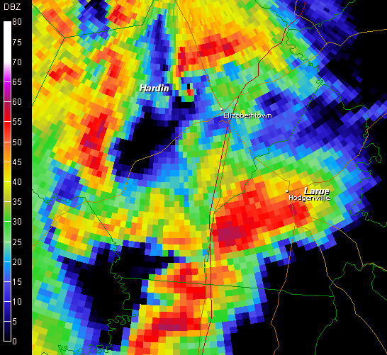
Base Reflectivity scan show a defined hook on the hardin co storm.
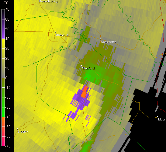
SRV and BV Scans show 2 areas of tornadic rotation


HARDIN COUNTY KENTUCKY
...STARTING POINT/TIME: ONE HALF MILE WEST-NORTHWEST OF CECILIA AT 243 PM EST
ENDING POINT/TIME: APPROX 2 MILES SOUTHEAST OF LONGVIEW AT 258 PM EST
FUJITA SCALE: MAINLY F1 WITH MAX F2 WHERE TORNADO CROSSED HIGHWAY 31W 3-4 MILES NORTH OF ELIZABETHTOWN
PATH LENGTH: DETAILS TO FOLLOW
PATH WIDTH: 100 YARDS AT INCEPTION TO ONE-QUARTER MILE AT MAX INTENSITY
DEATHS: 0
INJURIES: 0

LARUE COUNTY KENTUCKY...
STARTING POINT/TIME: APPROX 1-2 MILES EAST-SOUTHEAST OF UPTON NEAR EXIT 76 ON INTERSTATE65; TORNADO SKIPPED UP AND DOWN ALONG ITS PATH ENDING POINT/TIME: APPROX ONE MILE WEST OF BUFFALO
FUJITA SCALE: F1PATH LENGTH: APPROX SIX MILES
PATH WIDTH: DETAILS TO FOLLOW
DEATHS: 0
INJURIES: 0

100mph straight-line winds in Madison County
An official National Weather Service Storm Survey Team has determined that storm damage in Madison County from January 2, 2006 was due to straight-line winds.

It’s important to remember that straight-line winds can do even more damage than a weak tornado. Another good reason to take Severe Thunderstorm Warnings just as seriously as Tornado Warnings!

A LINE OF SEVERE THUNDERSTORMS MOVED THROUGH MADISON COUNTY ON MONDAY JANUARY 2. THIS LINE OF STORMS WAS ASSOCIATED WITH A VERY POWERFUL SYSTEM THAT WAS RESPONSIBLE FOR SEVERAL TORNADOES AND MUCH WIND DAMAGE ACROSS CENTRAL KENTUCKY.

AROUND 500 PM EST...A LINE OF SEVERE THUNDERSTORMS ENTERED MADISON COUNTY. THE STRONGEST PART OF THE STORMS MOVED JUST NORTH OF BEREA. A SITE SURVEY TEAM FROM THE LOUISVILLE NATIONAL WEATHER SERVICE OFFICE COMPLETED A STORM SURVEY THIS MORNING JUST NORTH OF BEREA.THE DAMAGE WAS CONCENTRATED IN A RELATIVELY SMALL AREA NEAR THE FOLLOWING LOCATIONS:
HERNDON LANE...
CARPENTER LANE...
AND IN THECHAPPEL ROAD AREA.

IN THE HERNDON LANE AND CARPENTER LANE AREAS... STRUCTURAL DAMAGE WAS OBSERVED WITH ROOFS BLOWN OFF TRAILERS...WINDOWS BROKEN OUT OFHOMES...AND MANY TREES DOWN. EYEWITNESSES DESCRIBED EVENTS CONSISTENT WITH THOSE GENERATED BY MICROBURSTS OR STRAIGHT LINE WIND TYPE DAMAGE.

IN THE CHAPPEL ROAD AREA... ONE MOBILE HOME SUSTAINED SIGNIFICANT ROOF AND STRUCTURAL DAMAGE. EYEWITNESSES AGAIN DESCRIBED EVENTS CONSISTENT WITH MICROBURSTS AND STRAIGHT LINE WIND TYPE DAMAGE.

THE COMBINATION OF OBSERVED DAMAGE ALONG WITH INTERVIEWS WITH EYEWITNESSES AND VIEWING ARCHIVED NATIONAL WEATHER SERVICE DOPPLER RADAR DATA LEFT LITTLE DOUBT THAT THE DAMAGE WAS CREATED BY STRAIGHT LINE WINDS. THOSE WINDS HAVE BEEN ESTIMATED UP TO 100 MPH.


6 Confirmed Tornadoes

The National Weather Service has confirmed that six tornadoes struck central Kentucky on January 2, 2006:

Lincoln County, F2...especially around McKinney...one minor injury (hospitalized and released)
Adair County, F2...east side of Columbia
Adair County, F1...northeast part of the county near Pellyton
Hardin County, F2...especially on the north side of Elizabethtown
Jefferson County, Kentucky, F1...far west side of town near Campground Road
Larue County, F1...from 2 miles southeast of Upton near Exit 76 on Interstate 65, skipped northeast for 6 miles to west of Buffalo


Storm Relative Velocity Scan showing strong tornadic rotation over Lincoln County in East Central Ky.

**KEY INFORMATION**
STARTING POINT/TIME: 3 MILES SOUTH OF MCKINNEY AT 434 PM

ESTENDING POINT/TIME: EAST OF US 27 NEAR HALLS GAP AT 448 PM

ESTMAXIMUM WIND SPEED: APPROX 130 MPH (F2 FUJITA SCALE)

PATH LENGTH: INTERMITTENT DAMAGE OCCURRED ALONG AN APPROXIMATELY 8.5 MILE LONG PATH.PATH

WIDTH: APPROX 200 YARDS MAXIMUM DEATHS: 0 INJURIES: 1 MINOR INJURY


SEVERE THUNDERSTORMS MOVED INTO LINCOLN COUNTY MONDAY AFTERNOON. ATORNADO TOUCHED DOWN ABOUT 3 MILES SOUTH OF MCKINNEY AT 434 PM EST.SEVERAL MOBILE HOMES AND OTHER SMALL STRUCTURES WERE DAMAGED ORDESTROYED. EYE WITNESSES DESCRIBED THE TORNADO AS IT TOUCHED DOWN.THE TORNADO THEN SKIPPED NORTHEAST 8.5 MILES TO ABOUT HALLSGAP...JUST EAST OF HIGHWAY 27 SOUTH OF STANFORD AROUND 448 PM EST.AT ONE LOCATION 2X6 BOARDS WERE FOUND FIRMLY EMBEDDED IN THE GROUND.ONE INJURY REQUIRING HOSPITALIZATION WAS REPORTED WHEN A BARN COLLAPSED ON A MAN.


More Storm Data to come

Tuesday, January 03, 2006

Jan 2, 2006 Severe Event Lexington

For a few days the SPC was calling for a significant severe weather episode for the entire midwest and southeastern states, A Moderate risk was posted for these areas.

Overnight a few storms erupted in the lexington area ... nothing major just a few boomers.. but as the mid day of the 2nd slowly ticked on a line of severe storms developed around MO and western KY and were moving east .. as the day wore of this line became very dangerous when it reached cental Ky. Severe warnings extended from the TN line up into IN with at least 7 tornado warnings in effect at the same time in KY. As this line got near lexington an area just to the SW was showing signs of a strong Mesocyclone as seen here..

also note the strong tornadic signature on the bottom of the image. eventually this storm lost a little strength as it drew closer to my area. but what we saw was still amazing for a jan storm.

Shortly after viewing this radar scan I decided to see what i could see from here so i went 1/2 block up the road to the school parking lot where wouldnt ya know a very defined gust front was approaching and fast...


I started snapping photos actually got 30 of em before the storm was way too close for comfort since i was on foot at the time as i was headed back home i noted a wall cloud just about overhead and to my SW with some good vertical motion and rotation.. as it passed over i got a few photos of that and took shelter inside as the rain and fairly gusty winds hit. wasnt as bad as it looked on radar We were spared this time.. a county south of me got hit hard by a tornado heres some of the images i captured.


Photos From Lexington