
Friday July 21, 2006 A HP supercell formed west of St Louis MO and was moving eastward thru-out the day causing numerous reports of wind damage from St louis into IL as it approached The Evansville area the HP transitioned into a Derecho event and triggering new storms out ahead of it into southern Indiana. . Still generating wind damage reports as it moved closer to the bluegrass region.
As the storms approached louisville the system started to lose its punch a bit It was still producing areas of winds up to 60 mph but was losing streanth as it made its way into the lexington area with several breaks in the leading edge.
I went and got into position about 45 min or so before it got into the area . The line was close enough to see the darkening to the west as it got closer.
After a short time a shelf cloud like feature made its way across the sky with winds gusting to around 30 mph. about 5-10 minutes after its passage the winds abruptly died off as if someone had turned off a fan... thinking that was odd i was looking eastward at the back side of the shelf cloud now a good distance away when i hearda low roaring noise.. I knew exactly what was comming as i turned and grabbed my radio gear and map off the roof of the car i seen the wind and rain comming across the rear field of the school as i jumped into the car the wind and heavy rain hit like a truck.
The wind was making my car bounce since it was parked sideways to the wind and it had the sound of like being in a high pressure car wash.. twigs and other debris from across the feild i guess was flying by.... as i looked at the tree in front of the golf course it had some branches and lots of leaves flying off of it and instead of falling they went off on an upward direction from where they came off never really seen where they came down but had to been at least a few hundred feet from the tree. then after about 3-5 min it was over with a light rain and some moderate wind gusts .. I estimated by the look of the trees and the effect on the car it was a good 50 mph or so...
Photos of this event are on the KYTHUNDER website under July 21, 2006 at the following link
Ky Thunder Images
Damage in fayette county consisted of numerous trees down and a few power poles broken and lines down from falling trees.
Sunday, July 23, 2006
Thursday, July 13, 2006
Wed July 12 Event
Two rounds of storms today. the first cell moved to the north of my location by about a mile got some good shots from the south side with a section that could have been a small shear vortex.
later on in the day we tracked a bowing line of storms coming up from the south. This looked to affect the area so i got things ready here and waited until the line was about 20 miles to the south. No warnings were issued for this line only the mention of strong storms in the area.
Not having a vehicle today i was limited to spotting from my home location i went to the corner of Camelot drive and watched the darkening sky to the south grow closer. as it did i started seeing features that at the time i figured was a shelf cloud... boy that was a mistake.. turns out as it got overhead and looking southeast there was a very large wall cloud with what looked like a visible mesocyclone towering above it. looking back to the west there were some lowerings with very fast vertical motion that i was told were funnels just not very organized...
after snapping a few pics that way i turned back to the wall cloud and noticed what looked like a small dark funnel poking out of the base a few seconds later the cloud base around it lowered and blocked my view of it and the rain Heavy rain and hail started falling blocking out that whole side of the storm winds peaked at 40-50 mph with almost white out conditions for about 5 minutes then the sky cleared quickly im thinking the wind was from the RFD ... over all it was a good storm.
you can see the photos of both storms here: July 12 2006 KYThunder Photos
Friday, May 26, 2006
Severe Storms this evening
Today we were under a moderate risk... Well it wasnt all that impressive it did have some nice structure some intense lightning but i was hoping for a little more out of the storms,
It was cool to have my bro mike along showing him my normal place for spotting..(hes not from around here if you had guessed allready) so it was cool to have him here for a severe event...
At one point after the gust front passed there was a suspicious area that a few of the skywarm spotters and I noticed but that had more of a horizontal overturning if you want to call it that.
But it was cool. my first severe weather net since i got my license so it was good to get out there and do what i love to do... alot of the photos i took i must have had the cam set wrong because they came out blurry... some look good some ehhhh keepers but not show'ers lol well thats all for this blog post....
Wednesday, April 19, 2006
Intense lightning Storm 4-19-06 4 Am Lexington
Started off as a boring night at work... Knowing storms were expected later on that night i hoped i would be outta there before they arrived.. and WOOT yes i was...
On the drive to the home area i could see the lightning off to the west and north as i drove west into it the lightning intensity exploded. IC and CG everywhere... i approximated at least a 200 spm flash rate now my digital camera only has a 2 second exposure but i was able to capture ALOT of photos from this electrically active storm.. Bolts were crashing down everywhere around the car and this went on for about 2 hrs.. boy was i having fun LOL.. Ill have photos posted soon... im actually starting to get backed up on my image posting so gimme some time
Peace everyone and 73'
Tuesday, April 11, 2006
Passed The Test
On sunday I Finally got around to getting to a test session for my ham license... and passed WOOT!!!.. and with a quickness was issued my callsign the next day .. Wow Talk about speedy service.... My Callsign is KI4OQQ and is a bit of a mouthfull to say so ill prolly be going to try and get an easier vanity CS soon.. Either way its cool and i got that over with....
and again WOOT
and again WOOT
April 7th Severe Events
On April 7th the first round of storms came into the area crossing the TN/KY line around logan county moving north east... Other Cells fired across the state but the storm in the south moved into barren county producing .75+ inch hail and numerous reports of funnel clouds. this storm eventually moved to the south of lexington. later in the evening around 9:25 Pm a lone supercell storm ahead of the main line of storms approached the county. This storm had well defined structure even seen in the dark. as the cell got into the county a severe thunderstorm warning was issued. from my location behind southern elementary school I noted what looked like a very large funnel cloud to my southwest approx 0.5 miles away shortly there after there was a breif period of .25 inch hail high winds and very heavy rains...
On further examination of the photo of the funnel there is a strong possibility it was in fact a tornado altho only slight tree damage was noted in a survey i conducted a few days later..
Image shows an extension below the funnel down to approx 100 ft with a visible debris poof directly below that.. i will be looking over radar archives to see if anything was visible on there.... I will update this when that is complete...
Tuesday, April 04, 2006
April 2 2006 Outbreak
A severe Weather event unfolded in the midwest on april 2nd and moved off the east coast by lat april 3rd, In all
April 2
April 3
April 2
- 64 Tornado Reports
- 380 Wind Reports (6) Very high wind
- 354 Hail Reports (28 Large Hail)
April 3
- 0 Tornado Reports
- 52 Wind Reports
- 106 Hail Reports
I will post more details and images of the events here in lexington soon.
Wind damage was numerous around the area and a wind speed of 82 Mph was recorded in Lexington
Tuesday, March 07, 2006
Severe Weather event unfolding for the Midwest
So far at this time we could be looking at a similar event as the April 3 1974 super outbreak.
Models are at a dissagreement at this time as to the placement and strength but either way a severe event is looking very possible in the next few days.
This is definatly something to keep an eye on if your in the midwest this week.
the battle of warm and cold air has returned to the middle US... lets all hope the warm air wins and boots the cold stuff outta here for the next several months..
As this event unfolds i will update the page here..
Until then.... Have fun and be safe out there
Sunday, February 19, 2006
Winter wont give up just yet
After hitting a high of 69 thursday a major cold front had to sweep thru the area dropping the temps down into the upper 20s for friday and the downslope continued until now...
Currently in lexington the temp is a sweaty 10 deg and it was snowing like a SOB this morning..... got about an inch ... we dont want it lol send it back to Canada gimmy my 85 deg and storms ill be happy... BTW the line of storms that came with the front didnt amount to anything but one flash of lightning and lots of heavy rain... Until next time....
Currently in lexington the temp is a sweaty 10 deg and it was snowing like a SOB this morning..... got about an inch ... we dont want it lol send it back to Canada gimmy my 85 deg and storms ill be happy... BTW the line of storms that came with the front didnt amount to anything but one flash of lightning and lots of heavy rain... Until next time....
Tuesday, February 14, 2006
Old Man Winter
Well Winter has returned with a vengeance.... Luckily this area was not in its sights for the major snow all we managed was about 3 inches a few days ago while the NE of the US got 12-18+ inches...
Way too much for me lol . well im sitting here waiting for spring to get here with the warm weather and the storms.... Theres a chance of thunderstorms this thursday so lets hope for something good ...
Thats all for now tune in later hehehe
Way too much for me lol . well im sitting here waiting for spring to get here with the warm weather and the storms.... Theres a chance of thunderstorms this thursday so lets hope for something good ...
Thats all for now tune in later hehehe
Wednesday, January 04, 2006
More Storm Data
Hardin and Larue County Tornadoes
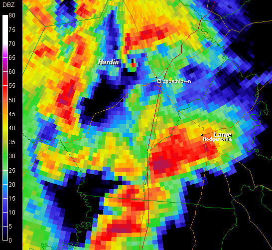


Base Reflectivity scan show a defined hook on the hardin co storm.
SRV and BV Scans show 2 areas of tornadic rotation
HARDIN COUNTY KENTUCKY
...STARTING POINT/TIME: ONE HALF MILE WEST-NORTHWEST OF CECILIA AT 243 PM EST
ENDING POINT/TIME: APPROX 2 MILES SOUTHEAST OF LONGVIEW AT 258 PM EST
FUJITA SCALE: MAINLY F1 WITH MAX F2 WHERE TORNADO CROSSED HIGHWAY 31W 3-4 MILES NORTH OF ELIZABETHTOWN
PATH LENGTH: DETAILS TO FOLLOW
PATH WIDTH: 100 YARDS AT INCEPTION TO ONE-QUARTER MILE AT MAX INTENSITY
DEATHS: 0
INJURIES: 0
LARUE COUNTY KENTUCKY...
STARTING POINT/TIME: APPROX 1-2 MILES EAST-SOUTHEAST OF UPTON NEAR EXIT 76 ON INTERSTATE65; TORNADO SKIPPED UP AND DOWN ALONG ITS PATH ENDING POINT/TIME: APPROX ONE MILE WEST OF BUFFALO
FUJITA SCALE: F1PATH LENGTH: APPROX SIX MILES
PATH WIDTH: DETAILS TO FOLLOW
DEATHS: 0
INJURIES: 0
100mph straight-line winds in Madison County
An official National Weather Service Storm Survey Team has determined that storm damage in Madison County from January 2, 2006 was due to straight-line winds.
It’s important to remember that straight-line winds can do even more damage than a weak tornado. Another good reason to take Severe Thunderstorm Warnings just as seriously as Tornado Warnings!
A LINE OF SEVERE THUNDERSTORMS MOVED THROUGH MADISON COUNTY ON MONDAY JANUARY 2. THIS LINE OF STORMS WAS ASSOCIATED WITH A VERY POWERFUL SYSTEM THAT WAS RESPONSIBLE FOR SEVERAL TORNADOES AND MUCH WIND DAMAGE ACROSS CENTRAL KENTUCKY.
AROUND 500 PM EST...A LINE OF SEVERE THUNDERSTORMS ENTERED MADISON COUNTY. THE STRONGEST PART OF THE STORMS MOVED JUST NORTH OF BEREA. A SITE SURVEY TEAM FROM THE LOUISVILLE NATIONAL WEATHER SERVICE OFFICE COMPLETED A STORM SURVEY THIS MORNING JUST NORTH OF BEREA.THE DAMAGE WAS CONCENTRATED IN A RELATIVELY SMALL AREA NEAR THE FOLLOWING LOCATIONS:
HERNDON LANE...
CARPENTER LANE...
AND IN THECHAPPEL ROAD AREA.
IN THE HERNDON LANE AND CARPENTER LANE AREAS... STRUCTURAL DAMAGE WAS OBSERVED WITH ROOFS BLOWN OFF TRAILERS...WINDOWS BROKEN OUT OFHOMES...AND MANY TREES DOWN. EYEWITNESSES DESCRIBED EVENTS CONSISTENT WITH THOSE GENERATED BY MICROBURSTS OR STRAIGHT LINE WIND TYPE DAMAGE.
IN THE CHAPPEL ROAD AREA... ONE MOBILE HOME SUSTAINED SIGNIFICANT ROOF AND STRUCTURAL DAMAGE. EYEWITNESSES AGAIN DESCRIBED EVENTS CONSISTENT WITH MICROBURSTS AND STRAIGHT LINE WIND TYPE DAMAGE.
THE COMBINATION OF OBSERVED DAMAGE ALONG WITH INTERVIEWS WITH EYEWITNESSES AND VIEWING ARCHIVED NATIONAL WEATHER SERVICE DOPPLER RADAR DATA LEFT LITTLE DOUBT THAT THE DAMAGE WAS CREATED BY STRAIGHT LINE WINDS. THOSE WINDS HAVE BEEN ESTIMATED UP TO 100 MPH.

6 Confirmed Tornadoes
The National Weather Service has confirmed that six tornadoes struck central Kentucky on January 2, 2006:
Lincoln County, F2...especially around McKinney...one minor injury (hospitalized and released)
Adair County, F2...east side of Columbia
Adair County, F1...northeast part of the county near Pellyton
Hardin County, F2...especially on the north side of Elizabethtown
Jefferson County, Kentucky, F1...far west side of town near Campground Road
Larue County, F1...from 2 miles southeast of Upton near Exit 76 on Interstate 65, skipped northeast for 6 miles to west of Buffalo

Storm Relative Velocity Scan showing strong tornadic rotation over Lincoln County in East Central Ky.
**KEY INFORMATION**
STARTING POINT/TIME: 3 MILES SOUTH OF MCKINNEY AT 434 PM
ESTENDING POINT/TIME: EAST OF US 27 NEAR HALLS GAP AT 448 PM
ESTMAXIMUM WIND SPEED: APPROX 130 MPH (F2 FUJITA SCALE)
PATH LENGTH: INTERMITTENT DAMAGE OCCURRED ALONG AN APPROXIMATELY 8.5 MILE LONG PATH.PATH
WIDTH: APPROX 200 YARDS MAXIMUM DEATHS: 0 INJURIES: 1 MINOR INJURY
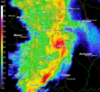
SEVERE THUNDERSTORMS MOVED INTO LINCOLN COUNTY MONDAY AFTERNOON. ATORNADO TOUCHED DOWN ABOUT 3 MILES SOUTH OF MCKINNEY AT 434 PM EST.SEVERAL MOBILE HOMES AND OTHER SMALL STRUCTURES WERE DAMAGED ORDESTROYED. EYE WITNESSES DESCRIBED THE TORNADO AS IT TOUCHED DOWN.THE TORNADO THEN SKIPPED NORTHEAST 8.5 MILES TO ABOUT HALLSGAP...JUST EAST OF HIGHWAY 27 SOUTH OF STANFORD AROUND 448 PM EST.AT ONE LOCATION 2X6 BOARDS WERE FOUND FIRMLY EMBEDDED IN THE GROUND.ONE INJURY REQUIRING HOSPITALIZATION WAS REPORTED WHEN A BARN COLLAPSED ON A MAN.
Lincoln County, F2...especially around McKinney...one minor injury (hospitalized and released)
Adair County, F2...east side of Columbia
Adair County, F1...northeast part of the county near Pellyton
Hardin County, F2...especially on the north side of Elizabethtown
Jefferson County, Kentucky, F1...far west side of town near Campground Road
Larue County, F1...from 2 miles southeast of Upton near Exit 76 on Interstate 65, skipped northeast for 6 miles to west of Buffalo
Storm Relative Velocity Scan showing strong tornadic rotation over Lincoln County in East Central Ky.
**KEY INFORMATION**
STARTING POINT/TIME: 3 MILES SOUTH OF MCKINNEY AT 434 PM
ESTENDING POINT/TIME: EAST OF US 27 NEAR HALLS GAP AT 448 PM
ESTMAXIMUM WIND SPEED: APPROX 130 MPH (F2 FUJITA SCALE)
PATH LENGTH: INTERMITTENT DAMAGE OCCURRED ALONG AN APPROXIMATELY 8.5 MILE LONG PATH.PATH
WIDTH: APPROX 200 YARDS MAXIMUM DEATHS: 0 INJURIES: 1 MINOR INJURY

SEVERE THUNDERSTORMS MOVED INTO LINCOLN COUNTY MONDAY AFTERNOON. ATORNADO TOUCHED DOWN ABOUT 3 MILES SOUTH OF MCKINNEY AT 434 PM EST.SEVERAL MOBILE HOMES AND OTHER SMALL STRUCTURES WERE DAMAGED ORDESTROYED. EYE WITNESSES DESCRIBED THE TORNADO AS IT TOUCHED DOWN.THE TORNADO THEN SKIPPED NORTHEAST 8.5 MILES TO ABOUT HALLSGAP...JUST EAST OF HIGHWAY 27 SOUTH OF STANFORD AROUND 448 PM EST.AT ONE LOCATION 2X6 BOARDS WERE FOUND FIRMLY EMBEDDED IN THE GROUND.ONE INJURY REQUIRING HOSPITALIZATION WAS REPORTED WHEN A BARN COLLAPSED ON A MAN.
More Storm Data to come
Tuesday, January 03, 2006
Jan 2, 2006 Severe Event Lexington
For a few days the SPC was calling for a significant severe weather episode for the entire midwest and southeastern states, A Moderate risk was posted for these areas.
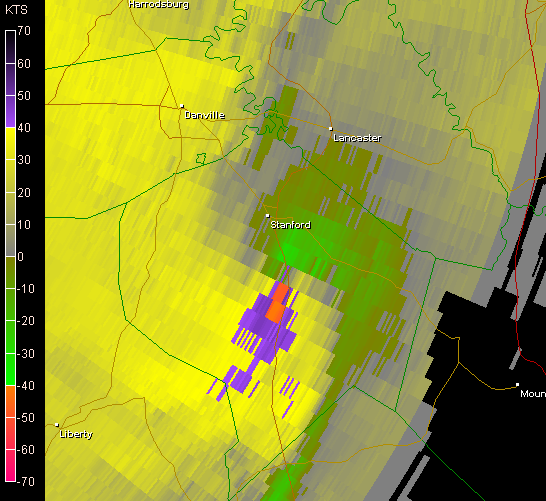
Overnight a few storms erupted in the lexington area ... nothing major just a few boomers.. but as the mid day of the 2nd slowly ticked on a line of severe storms developed around MO and western KY and were moving east .. as the day wore of this line became very dangerous when it reached cental Ky. Severe warnings extended from the TN line up into IN with at least 7 tornado warnings in effect at the same time in KY. As this line got near lexington an area just to the SW was showing signs of a strong Mesocyclone as seen here..

also note the strong tornadic signature on the bottom of the image. eventually this storm lost a little strength as it drew closer to my area. but what we saw was still amazing for a jan storm.
Shortly after viewing this radar scan I decided to see what i could see from here so i went 1/2 block up the road to the school parking lot where wouldnt ya know a very defined gust front was approaching and fast...
 I started snapping photos actually got 30 of em before the storm was way too close for comfort since i was on foot at the time as i was headed back home i noted a wall cloud just about overhead and to my SW with some good vertical motion and rotation.. as it passed over i got a few photos of that and took shelter inside as the rain and fairly gusty winds hit. wasnt as bad as it looked on radar We were spared this time.. a county south of me got hit hard by a tornado heres some of the images i captured.
Photos From Lexington
Overnight a few storms erupted in the lexington area ... nothing major just a few boomers.. but as the mid day of the 2nd slowly ticked on a line of severe storms developed around MO and western KY and were moving east .. as the day wore of this line became very dangerous when it reached cental Ky. Severe warnings extended from the TN line up into IN with at least 7 tornado warnings in effect at the same time in KY. As this line got near lexington an area just to the SW was showing signs of a strong Mesocyclone as seen here..
also note the strong tornadic signature on the bottom of the image. eventually this storm lost a little strength as it drew closer to my area. but what we saw was still amazing for a jan storm.
Shortly after viewing this radar scan I decided to see what i could see from here so i went 1/2 block up the road to the school parking lot where wouldnt ya know a very defined gust front was approaching and fast...
I started snapping photos actually got 30 of em before the storm was way too close for comfort since i was on foot at the time as i was headed back home i noted a wall cloud just about overhead and to my SW with some good vertical motion and rotation.. as it passed over i got a few photos of that and took shelter inside as the rain and fairly gusty winds hit. wasnt as bad as it looked on radar We were spared this time.. a county south of me got hit hard by a tornado heres some of the images i captured.Photos From Lexington


Subscribe to:
Comments (Atom)